
A Continent Hidden Beneath the Ocean — Zealandia
- 演化之聲

- Mar 9
- 3 min read
Updated: Apr 11
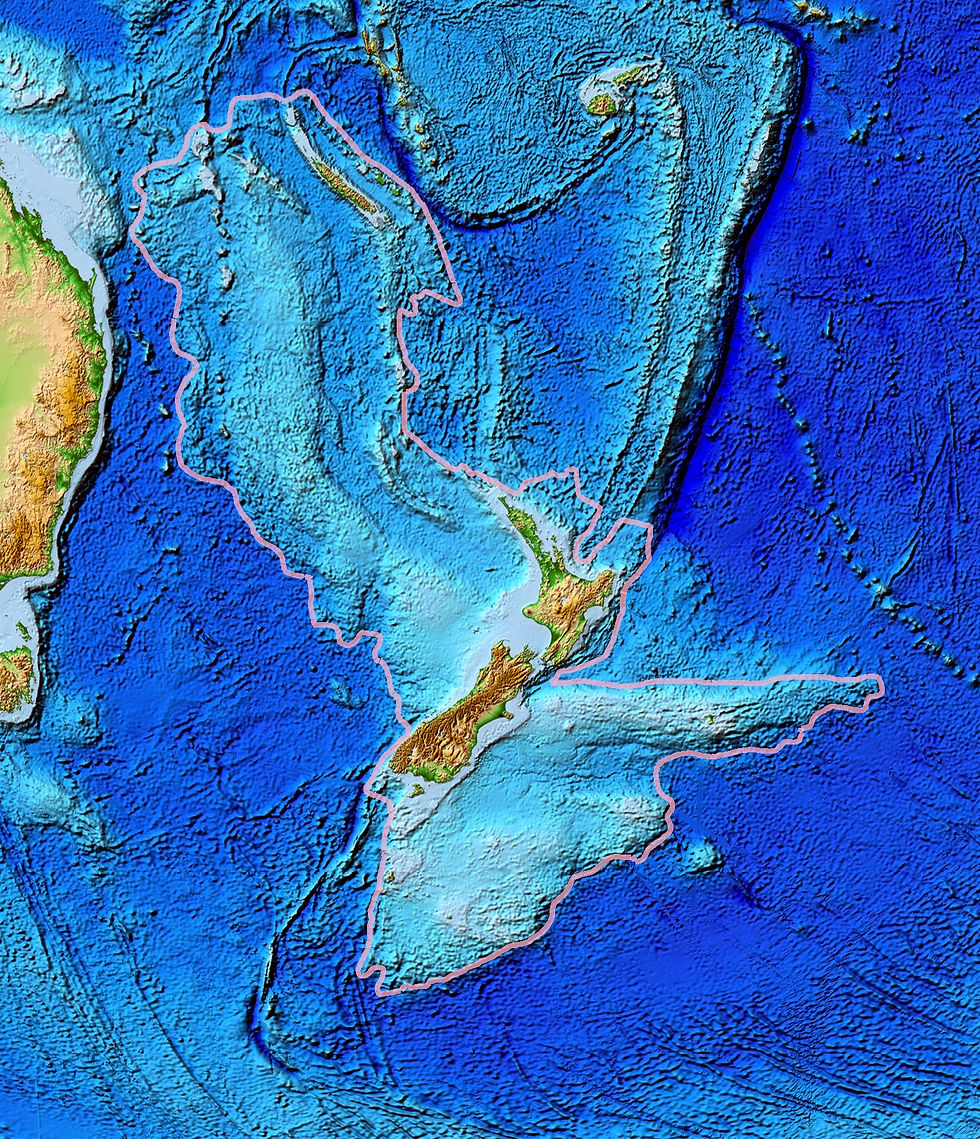
New Zealand is widely known as a land famous for its unusual birds. In the public imagination, it appears to be a large island divided into the North Island and the South Island. However, few people truly understand the geological reality behind this landmass. Geological and bathymetric data accumulated over the past several decades reveal that the waters surrounding New Zealand contain extensive submerged plateaus, ridges, and grabens, including features such as the Campbell Plateau and the Norfolk Ridge. These regions generally lie above the 2,500-meter bathymetric contour.
Rock samples collected from these submerged regions match the composition of the igneous rocks found on the islands of New Zealand. In addition, their geological characteristics satisfy the criteria for continental crust. For this reason, geologists concluded that New Zealand sits upon a largely submerged continental block. In 1995, geologist Bruce Luyendyk named this continent Zealandia.

Zealandia covers an area of approximately 4.9 million square kilometers, yet more than 90 percent of the continent lies beneath sea level. It is separated from the Australian continent by the Cato Trough, which reaches depths of about 3,600 meters and is floored by oceanic crust. The presence of oceanic crust between the two regions demonstrates that New Zealand is not simply an uplifted fragment of the Australian continental crust.
Zealandia originated as a marginal portion of the southern supercontinent Gondwana. Around 170 million years ago, Africa and South America began separating from Gondwana. About 40 million years later, India and Madagascar broke away. Subsequently, Africa and South America drifted apart, leading to the opening of the Atlantic Ocean. Around 80 million years ago, during the Late Cretaceous, Zealandia rifted away from Gondwana and separated from both Australia and Antarctica. During this time the Tasman Sea formed between the landmasses. The complete process of separation lasted roughly 20 million years, and during this interval most of Zealandia gradually subsided beneath the ocean.
Because Zealandia was once connected to both Australia and Antarctica, the region shares a common biological heritage derived from the Gondwanan ecosystems of the Mesozoic. Some species in Zealandia represent descendants of those ancient Gondwanan lineages, while geographic isolation after continental separation also produced distinctive endemic fauna. Examples include the kiwi, the extinct moa, and the extinct Saint Bathans mammals.

In the early Paleocene, the ecosystems of New Zealand were still recovering from the extinction of the dinosaurs. Surviving organisms gradually filled ecological niches that had become vacant. At that time, much of Zealandia consisted of low-lying terrain, wetlands, and shallow marine environments. Fossils from this period include early penguins such as the giant penguin Kumimanu, as well as numerous species of seabirds.
During the Chattian stage of the Oligocene, the area of land above sea level in Zealandia reached its minimum extent, shrinking to roughly one quarter of the present-day land area of New Zealand. Some researchers once proposed that the continent may have been almost entirely submerged at this time, which would have caused the extinction of all terrestrial organisms, with modern species arriving only after the Oligocene by crossing the ocean. However, fossil evidence indicates that the ancestors of birds such as the kiwi, moa, and acanthisittid wrens were already present before the continental separation, implying that some land areas must have remained above water.
Nevertheless, analyses of mitochondrial DNA reveal that these birds experienced a genetic bottleneck during this period, suggesting that their population sizes declined drastically as the amount of available land decreased.
After the Miocene, tectonic activity along the Alpine Fault on New Zealand's South Island led to the uplift of the Southern Alps. Fossils discovered within the Manuherikia Group in the South Island reveal the Saint Bathans fauna, which includes small mammals and crocodilians. Fossils of moa, the primitive kiwi Proapteryx, and the ancient acanthisittid wren Kuiornis have also been recovered from these deposits.

Through this evidence, it becomes clear that Zealandia is not merely a fragmented continental remnant submerged beneath the ocean. Rather, it is a coherent continent with an area comparable to that of India. The fossil record preserved within this largely submerged landmass may be as rich as that of other continents. Yet New Zealand has yielded very few fossils of non-avian dinosaurs. Future discoveries may reveal many more fossils from this hidden continent, and with further research we may gain a deeper understanding of the prehistoric life that once inhabited Zealandia.
Author: Shui Ye-You
References:
1. Mortimer, N . et al. (2006). Zealandia: Earth’s Hidden Continent. The Geological Society of America.
2. Mortimer, N. (2008). Zealandia. GNS Science.


Comments